I am interested in purchasing another RS to slowly build a network for citizen scientists in Fiji. I already have a station in Suva, Fiji and I am able to access an IRIS station about 60km away from my station. However, a third station in this area would be better as I would be able to better triangulate earthquake epicentres - with 2 it is quite hard. My main interest is to capture small local earthquakes that are not reported by global agencies.
If I was to purchase one more RS, would I be able to triangulate earthquake epicentres using the new one plus the existing 2?
Also is there any automated way to triangulate the epicentres and add them to the Shakenet app or would I need to manually use the P and S wave picks from each three stations on a program like Swarm?
What I do at the moment is use my station and the IRIS station and carefully make P and S wave picks to determine its distance and the map automatically draws two circles and show where they intersect. I was just wondering if with 3 stations it will be easier and if it can be automated and added to shakenet app in the events list.
I use 4 or 5 RS1s (my own 2, plus others in my region) to locate the epicentre and it does pretty well. I’m not sure how well it will work with only 3 sensors.
However, I have not had success with the magnitude. It is always underestimated.
I would also suspect that triangulation would depend on the separation of each instrument. I doubt if there would be much difference in arrival times noticed if they were relatively close.
Yours is a fantastic endeavour, I follow your account on Twitter and your descriptive posts are always interesting to read. Especially because some of the stronger quakes that happen in your region of the world can be seen on instruments even here in Scotland, on the other side of the planet.
The principle is that the more data sources you have, the better you will be able to identify local events, as I am sure you have already imagined. However, even with three stations you can start the project and then proceed from there.
Unfortunately, for now, we are not able to pull in earthquake solutions from hobbyists and show them on ShakeNet. Maybe this will change in the future and we are always working to improve our services.
Regarding triangulation, are you aware of our locator.raspberryshake.org service? Maybe you can investigate that one and see if it can help in what you want to achieve. Otherwise, yes, SWARM would be another solution with its manual picking feature.
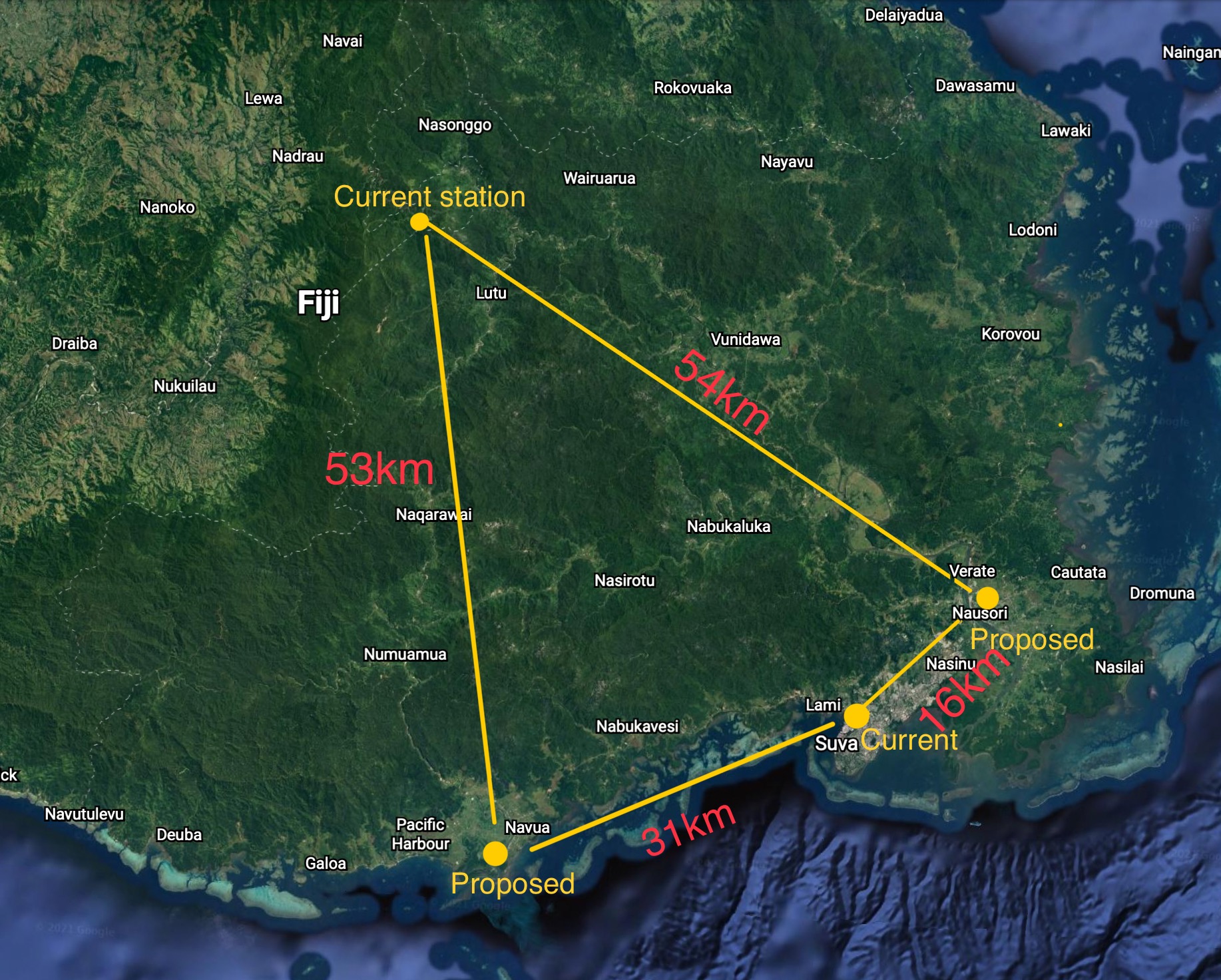
I currently use two stations which are located about 58km apart from each other. I plan to add 2 more. I have added a photo of a map below showing current stations I use and the 2 proposed ones locations along with the distance in between. I suppose this spacing should be good enough to detect small local quakes within this area? Thanks!
Thanks! It is important to raise awareness in areas like Fiji where earthquakes occur but awareness is relatively low. Interesting they are detected all the way in Scotland!
Does the locator tool only work for events that are listed or also for waveforms? The quakes I am interested in locating are usually not reported and listed anywhere as they are below M4 and so not reported. I guess for that SWARM would be best?
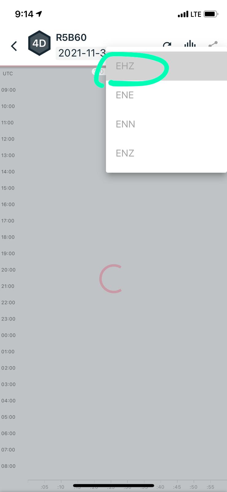
Also, for the difference between the 1D and 4D, I know the 1D only has a vertical sensor whereas the 4D has 3 additional multidirectional sensors - does this mean the 1D will only have the EHZ channel and not ENE, ENN and ENZ like the 4D as shown in the image below? Apart from that, does the 1D have any other limitations in recording the same event if I were to use a combination of 1D and 4D?
It definitely is! And yes, I was surprised too when I could see the waves rolling in after around 20 minutes after the event origin time up here in Scotland. Definitely unexpected!
For now, yes, the locator tool can be used with events that are on our list. This list will be expanded more and more in the coming months, so it is possible that you will be able to use it even with events that are not listed right now.
Regarding the differences between the 1D and the 4D, you are correct. They offer the same EHZ geophone vertical sensor, but the 4D has three more three-directional accelerometers, one in the vertical axis (ENZ) and two for the remaining horizontal axes (ENN, ENE).
The only difference would be that the 1D will record the same event that a close-by 4D will see, but only in the vertical channel.
The fact that ENE, ENN, ENZ channels look very similar to each other and show little to no disturbance compared to the EHZ is because the accelerometers are designed for larger earth movements, and what is recorded as small on the geophone (EHZ) will not be seen by the accelerometers.
On the opposite side, when in the case of a strong event happening nearby, for example, the signal from the geophone can get saturated, while the accelerometers will continue to record it without issues, enabling perfect scaling of the recorded data.
Is there any association between movement on the ENE, ENN and ENZ channels and ground shaking? For example the EHZ channel shows nearby earthquakes but not on the other channels, I suppose as they are too small. But a few events in the region which were strong enough to be felt where I am were picked up slightly on the ENE and ENN channels.
Yes, as you already know, the EHZ (ENZ) (vertical channel) shows how the ground moved in the “up and down” direction (along the Z axis) and is the primary reference for earthquake detection and analysis, which is why all of our Shakes have a sensor which can record data for this direction.
ENN instead shows movement for one of the two horizontal directions, showing the Earth’s latitudinal motion along the North to South axis. ENE shows the movement for the second horizontal direction, showing the Earth’s longitudinal motion along the East to West axis.
So, you can imagine that your Shake is at the center of a frame of reference, and it is able to capture data coming along every one of the three axis that form the same reference frame. Usually, the data along the vertical axis can be the most evident, but there are situations where the side-by-side movements caused by certain seismic waves will be more visible than the expected up-and-down shaking.